


Kinosternon abaxillare, 128
Kinosternon abaxillare Baur in Stejneger 1925 –
Central Chiapas Mud Turtle, Casquito Pardo
Eduardo Reyes-Grajales1,2, John B. Iverson3,
Andrew D. Walde2, and Thomas S. Akre4
1Departamento de Conservación de la Biodiversidad, El Colegio de la Frontera Sur,
San Cristóbal de Las Casas, Chiapas, Mexico [[email protected]];
2Turtle Survival Alliance, North Charleston, South Carolina, 29406 USA [[email protected]];
3Department of Biology, Earlham College, Richmond, Indiana 47374 USA [[email protected]];
4Smithsonian National Zoo and Conservation Biology Institute, Front Royal, Virginia, 22630 USA [[email protected]]
Summary. – The Central Chiapas Mud Turtle, Kinosternon abaxillare (family Kinosternidae), is a medium-sized freshwater turtle (females to 162 mm straight-midline carapace length [SCL], males to 158 mm SCL). It is a monotypic species closely related to K. albogulare and K. scorpioides (sensu stricto). Populations are found in the Central Depression and Plateau of Chiapas, Mexico, and a small area of adjacent western Guatemala, where they occur in lentic and lotic habitats in deciduous and sub-deciduous forests and pine-oak forests, as well as highly altered areas of the Rio Grijalva watershed basin. The known elevation range is from 300 to 1600 m a.s.l. Although primarily aquatic, individuals make overland movements and estivate terrestrially near their aquatic habitats. The species is omnivorous with a diet that tends to reflect food availability. Clutch size is correlated with female body size and ranges from 1 to 6 eggs. Egg size ranges from 22 to 32 mm in length, 14 to 20 mm in width, and 4.5 to 6.3 g. Clutches are deposited throughout the year, similar to other tropical Kinosternon species. The loss and degradation of natural aquatic habitats, including lakes, permanent ponds, streams, and ciénegas, is the primary threat to the species. In addition, collection for food or pet trade continues to negatively impact wild populations across its distribution. The ecology and conservation status of K. abaxillare has been studied in recent years, mainly in the western portion of the central depression of Chiapas. Two protected natural areas in Mexico include this turtle as a priority species in their management plans.
Distribution. – Guatemala and Mexico. Endemic to the upper Rio Grijalva watershed of central Chiapas, Mexico, and adjacent western Guatemala. In Chiapas, it occurs in the Central Depression and in the central and southern portion of the central plateau. It is also found in the adjacent department of Huehuetenango, Guatemala.
Synonymy. – Kinosternon abaxillare Baur in Stejneger 1925, Kinosternon scorpioides abaxillare, Kinosternon cruentatum abaxillare.
Subspecies. – None recognized.
Status. – IUCN 2025 Red List: Vulnerable (VU A2cd+4cd); assessed 2021); CITES: Appendix II (2023).
Citation:
Reyes-Grajales, E., Iverson, J.B., Walde, A.D., and Akre, T.S. 2025. Kinosternon abaxillare Baur in Stejneger 1925 – Central Chiapas Mud Turtle, Casquito Pardo. In: Rhodin, A.G.J., Iverson, J.B., van Dijk, P.P., Stanford, C.B., Goode, E.V., Buhlmann, K.A., and Mittermeier, R.A. (Eds.). Conservation Biology of Freshwater Turtles and Tortoises: A Compilation Project of the IUCN/SSC Tortoise and Freshwater Turtle Specialist Group. Chelonian Research Monographs 5(19):128.1–13. doi: 10.3854/crm.5.128.abaxillare.v1.2025; www.iucn-tftsg.org/cbftt/.
Adobe Acrobat 6.0 or later required)
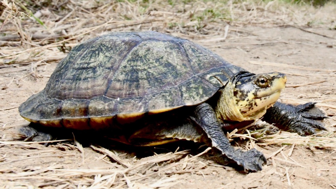
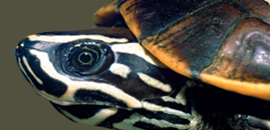
Adult female Kinosternon abaxillare from Villa Hidalgo, Chiapas, Mexico.
Photo by Eduardo Reyes-Grajales.
Distribution:
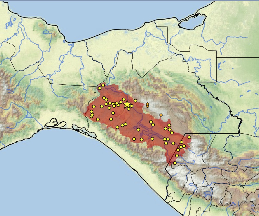
Distribution of Kinosternon abaxillare in Mexico and Guatemala. Yellow dots = museum and occurrence records of native population based on literature records (Iverson 1992, TTWG 2021; TTWG, in press); orange dots = probable trade or translocated specimens at high altitudes >1800 m a.s.l.; star = type locality. Colored shading = estimated historical indigenous range. Distribution is based on fine-scaled GIS-defined level 12 HUCs (hydrologic unit compartments) constructed around verified localities and then adding HUCs that connect known point localities in the same watershed or physiographic region, and similar habitats and elevations as verified HUCs, based Buhlmann et al. (2009), TTWG (2021), and TTWG (in press), and adjusted based on data from the authors. Map by Anders Rhodin, Chelonian Research Foundation.