


Graptemys pseudogeographica, 124
Graptemys pseudogeographica (Gray 1831) –
False Map Turtle, Mississippi Map Turtle
Peter V. Lindeman1 and Richard C. Vogt2,3
1Department of Biology, Earth, and Environmental Sciences,Â
Pennsylvania Western University at Edinboro,Â
Edinboro, Pennsylvania 16444 USA [[email protected]];
2Instituto Nacional de Pesquisas da AmazÈnia (INPA),Â
Coordenação de Pesquisa em Biologia Aquática, Manaus, Amazonas, Brazil;
3Deceased
Summary. – The False Map Turtle, Graptemys pseudogeographica (family Emydidae), is a medium-sized, strongly sexually dimorphic freshwater turtle species (males to 14.1 cm midline SCL and 12.1 cm midline PL, to 364 g; females to 26.3 cm midline SCL and 23.9 cm midline PL, to 2952 g). It is common to abundant in large rivers and oxbow lakes within the Mississippi River drainage of the central United States and other western Gulf Coast rivers. Two subspecies are recognized: G. p. pseudogeographica and G. p. kohnii. The ecology of this species has been relatively well studied. Males mature in their third or fourth year and females later, in their eighth to eleventh year. Typically, three (but up to four) clutches are laid in one year, with clutch sizes averaging 6.6–14.1 eggs in a population but as high as 22 eggs. Hatchlings emerge in the late summer and early fall. Males feed primarily on aquatic insects, bivalve mollusks, and algae, while females feed primarily on bivalve mollusks, snails, aquatic insects, fish carrion, and algae. Populations are fairly robust and the species does not appear to need any specific conservation measures at the present time, although nesting sites along riverine sandbanks are increasingly threatened and populations should be monitored for potential declines.
Distribution. – USA. Occurs in the larger rivers of the Mississippi River Basin, from the St. Croix and Wisconsin Rivers in northern Wisconsin and the Mississippi and Minnesota rivers in Minnesota southward to Louisiana and westward into Missouri, Kansas, and Oklahoma, in the Missouri River northward into North Dakota, and in the Ohio River eastward into the lower Tennessee and lower Cumberland rivers in western Tennessee and Kentucky and the Wabash River in Indiana. Also occurs in isolated river drainages west of the lower Mississippi along the western Gulf Coast: the Mermentau, Calcasieu, Sabine, Neches, Trinity, Brazos, and San Bernard drainages in Louisiana and Texas.
Synonymy. – Emys pseudogeographica Gray 1831, Clemmys pseudogeographica, Graptemys pseudogeographica, Malacoclemmys pseudogeographicus, Malacoclemmys pseudogeographica, Malaclemys pseudogeographica, Graptemys pseudogeographica pseudogeographica, Malaclemys pseudogeographica pseudogeographica, Malacoclemmys kohnii Baur 1890, Graptemys kohnii, Graptemys pseudogeographica kohnii, Malaclemys kohni.
Subspecies. – Two subspecies are currently recognized: Graptemys pseudogeographica pseudogeographica, False Map Turtle or Northern False Map Turtle, and Graptemys pseudogeographica kohnii, Mississippi Map Turtle.
Status. – IUCN 2023 Red List: Least Concern (LC), assessed 2011; CITES: Appendix II as Graptemys sp. (2023).
Citation:
Lindeman, P.V. and Vogt, R.C. 2024. Graptemys pseudogeographica (Gray 1831) – False Map Turtle, Mississippi Map Turtle. In: Rhodin, A.G.J., Iverson, J.B., van Dijk, P.P., Stanford, C.B., Goode, E.V., Buhlmann, K.A., and Mittermeier, R.A. (Eds.). Conservation Biology of Freshwater Turtles and Tortoises: A Compilation Project of the IUCN/SSC Tortoise and Freshwater Turtle Specialist Group. Chelonian Research Monographs 5(18):124.1–19. doi: 10.3854/crm.5.124.pseudogeographica.v1.2024; www.iucn-tftsg.org/cbftt/.
Adobe Acrobat 6.0 or later required)
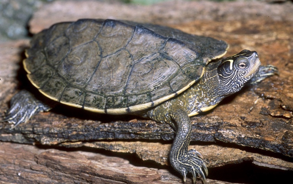
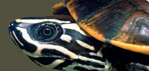
Adult male Graptemys pseudogeographica pseudogeographica, Indiana.
Photo by James H. Harding.
Distribution:
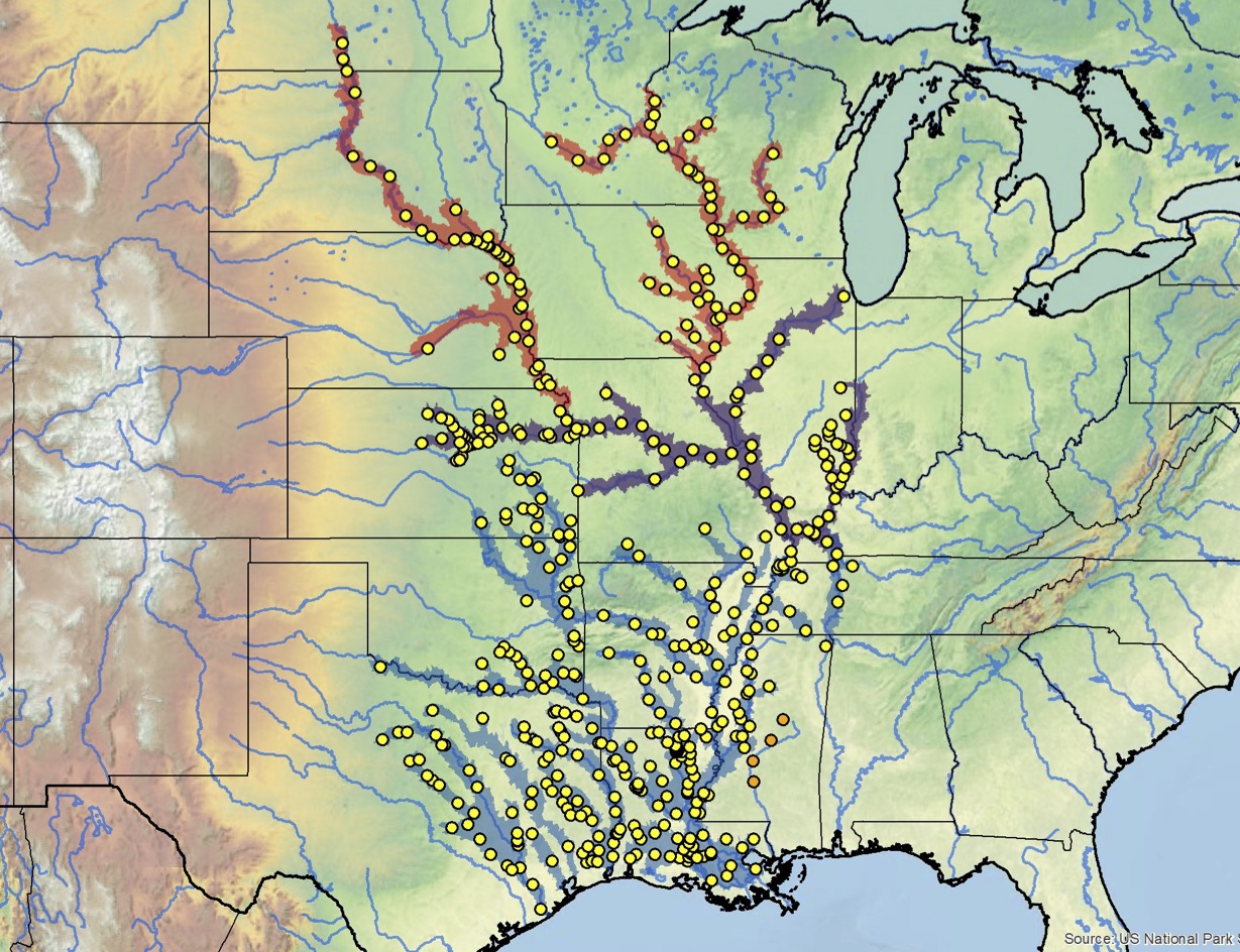
Distribution of Graptemys pseudogeographica in the USA. Yellow dots = museum and literature occurrence records of native populations based on Iverson (1992), other more recent literature records (see TTWG 2017, 2021), and authors’ additional data; orange dots = possibly introduced or translocated specimens; colored shading = estimated historical indigenous ranges of: 1) G. p. pseudogeographica = red, and 2) G. p. kohnii = blue; purple-colored overlap areas = presumptive intergrades. Distribution based on fine-scaled GIS-defined level 12 HUCs (hydrologic unit compartments) constructed around verified localities and then adding HUCs that connect known point localities in the same watershed or physiographic region, and similar habitats and elevations as verified HUCs based on Buhlmann et al. (2009), TTWG (2017, 2021), and data from authors and other sources.