Pelusios niger, 105
Pelusios niger (Duméril and Bibron 1835) –
West African Black Mud Turtle
Luca Luiselli1,4,5, Roger Bour2, Fabio Petrozzi3,
Godfrey C. Akani4, and Gabriel H. Segniagbeto5
1Institute for Development, Ecology, Conservation and Cooperation,
via G. Tomasi di Lampedusa 33, 00144 Rome, Italy [[email protected]];
2Reptiles & Amphibiens, UMR 7205 OSEB, Département de Systématique & Evolution,
Muséum national d’Histoire naturelle, 25 rue Cuvier, 75005 Paris, France [[email protected]];
3Ecologia Applicata Italia s.r.l., Rome, Italy [[email protected]];
4Department of Applied and Environmental Biology, Rivers State University of Science and Technology,
Port Harcourt, Nigeria [[email protected]];
5Département de Zoologie et Biologie Animale, Faculté des Sciences, Université de Lomé,
BP 1515, Lomé, Togo [[email protected]]
Summary. – The West African Black Mud Turtle, Pelusios niger (Family Pelomedusidae), is a freshwater turtle of medium size (carapace length to 35.5 cm) endemic to permanent wetlands in forested areas of West Africa, and is recognizable within the genus by its hooked maxillary beak. A median keel on the posterior vertebral scutes persists throughout life. The wide, blackish plastron is either uniformly dark or bears a lighter streak along the midline seam. Its field ecology has been studied extensively and quantitatively only in southern Nigeria, with home range, habitat selection, and food habits having been analyzed. The species is omnivorous (but predominantly carnivorous), with dietary composition shifting by season and by site, and also in relation to the extent of pollution of its habitat. Adult sex-ratio is even (1:1). Pelusios niger may potentially be a competitor of P. castaneus in forest water bodies of southern Nigeria, and especially in oil-polluted areas, due to an increased niche similarity between these species along the spatial and food niche axes. The species is locally abundant (especially in Nigeria and in Gabon), and its populations appear to be relatively stable. Nonetheless, its main habitats (i.e., forest streams and rivers inside the continuous forest zone) are under threat, and loss of habitat may cause a decline of the populations of this species in the years to come.
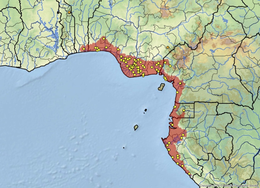
Distribution. – Benin, Cameroon, Equatorial Guinea, Gabon, Nigeria, Togo (?). The species has a coastal range in eastern West Africa from Benin (and possibly Togo) to Gabon.
Synonymy. – Sternotherus niger Duméril and Bibron 1835, Sternothaerus niger, Sternothaerus (Anota) niger, Pelusios niger, Sternothaerus oxyrhinus Boulenger 1897, Sternothaerus heinrothi Kanberg 1924.
Subspecies. – None recognized at present.
Status. – IUCN 2018 Red List Status: Least Concern (LC, assessed 1996, not listed); TFTSG Draft Red List: Near Threatened (NT, assessed 2013); CITES: Not listed.
Citation:
Luiselli, L., Bour, R., Petrozzi, F., Akani, G.C., and Segniagbeto, G.H. 2018. Pelusios niger (Duméril and Bibron 1835) – West African Black Mud Turtle. In: Rhodin, A.G.J., Iverson, J.B., van Dijk, P.P., Stanford, C.B., Goode, E.V., Buhlmann, K.A., Pritchard, P.C.H., and Mittermeier, R.A. (Eds.). Conservation Biology of Freshwater Turtles and Tortoises: A Compilation Project of the IUCN/SSC Tortoise and Freshwater Turtle Specialist Group. Chelonian Research Monographs 5(12):105.1–8. doi: 10.3854/crm.5.105.niger.v1.2018; iucn-tftsg.org/cbftt/.
(Adobe Acrobat 6.0 or later required)

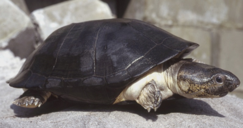
Pelusios niger, adult male, from Gamba, Gabon.
Photo by J. Maran.
Distribution:

Historic distribution of Pelusios niger in western and central Africa. Yellow dots = museum and literature occurrence records of native populations based on Iverson (1992) plus more recent and authors’ data; orange dots = uncertain native or trade or introduced specimens; red shading = projected historic distribution. Distribution based on GIS-defined level 10 HUCs (hydrologic unit compartments) constructed around verified localities and then adding HUCs that connect known point localities in the same watershed or physiographic region, and similar habitats and elevations as verified HUCs (Buhlmann et al. 2009; TTWG 2017), and adjusted based on authors’ subsequent data.


